Last week my family traveled to Oregon for an end-of-summer trip. We wanted to start in Bend, in the central part of the state. There we would hike and explore a bit—somewhat to her dismay, I was especially eager to take my daughter up South Sister, one of the Three Sisters volcanoes—before driving down to Ashland to see a couple of plays at the Oregon Shakespeare Festival. After that we would head to the coast and make our way home to Seattle.
That was the plan, at any rate. Then the wildfires laughed and had their say. The day before we were to leave, one blew up a few miles north of Bend. Named the Flat Fire, it blazed over the landscape, driven by hot dry winds and abundant fuels. People who lived in its path were ordered to evacuate. Smoke poured into Bend and the surrounding communities. Air quality dots in the area went from yellow (Moderate) to red (Unhealthy), purple (Very Unhealthy), and even maroon (Hazardous).
Wildfires have been a feature of Pacific Northwest summers for a while now. Even as one whose home has never been threatened, I find the start of the burning season unsettling. The fires can have a dreadful randomness. Look at a map of the western states. Within that vast territory all it takes is a lightning strike, a branch falling on a power line, a kid throwing a fire cracker, a federal employee burning a love letter, and a tree starts to burn, and then another. Thousands of acres later, the sky looks like something out of a J.M.W. Turner painting, while the air rasps your throat on its way to your lungs.
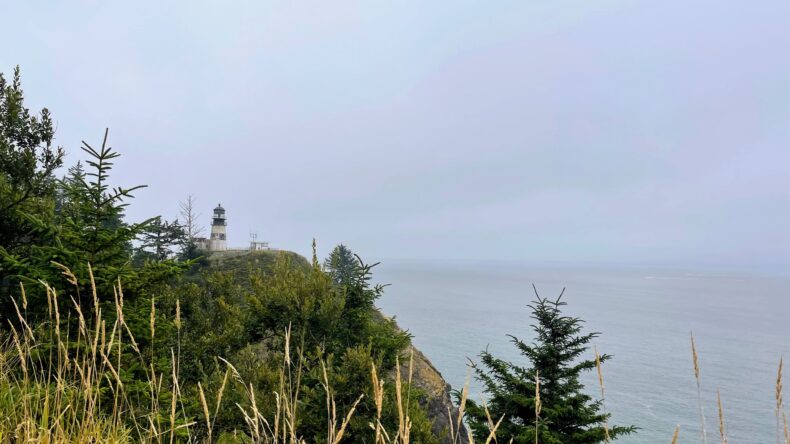
Anyway, we did not go to Bend. Instead I found the last available campsite at a state park on the Washington coast. We arrived under a low cloud ceiling with intermittent sun and light breezes. The cool weather was pleasant, but our enjoyment was muted somewhat by the knowledge that it was mild only because a high pressure ridge was keeping the inland toasty, the forests burning.
Walking on the beach or the headlands above, I checked for updates from the Flat Fire. “I don’t think we’re going to make it to Bend,” my wife said. “Just be here.” But I was not, or not entirely. I had been looking forward to hiking South Sister for months, had managed to secure climbing permits that were quite hard to get. Meanwhile the fire doubled in size to nine thousand acres, and the next day doubled again, to nearly twenty thousand acres. Four homes burned. The air quality dots stayed red, purple, maybe at best orange (Unhealthy for Sensitive Groups). Another fire had started, too, the Emigrant Fire. This one was more than sixty miles south of Bend, though, so I decided not to worry about it.
After a few nights on the coast we drove down to Ashland, where the air quality dots were mostly yellow. That night we saw Oscar Wilde’s The Importance of Being Earnest, an amusing farce about a small group of moneyed, entitled people who play fast and loose with convention and good sense for their own amusement, but somehow make it through unscathed in the end. (The festival offers insurance against smoke, should a performance have to be cancelled due to fires.)
Back at our hotel, reading through press releases about degrees of containment (10%, 20%, 27%) and balancing those against smoke forecasts, I made the case that the Flat Fire appeared to be under control thanks to the heroic efforts of interagency fire crews. The air quality dot closest to South Sister, at Mount Bachelor, had been consistently yellow for hours. In fact, if you squinted, you could see an imaginary but fairly well-defined line demarcating the mostly good air from the unquestionably bad air. South Sister was on the good side of that line. Maybe we could make Bend work after all.
“Fine,” my wife sighed. “Let’s give it a shot.”
“Great!” I said.
“So we have to climb South Sister?” my daughter asked.
“You bet!” I said.
“Yay,” she deadpanned.
Early the next morning, while my wife and daughter slept, I crept out to go to Mount McLoughlin, about an hour outside of Ashland. Mount McLoughlin is a stratovolcano in the classical style, with straight steep slopes leading to a sharp point of a peak. The sky was a perfect blue as I scrambled up. At the summit, I settled into a nice rocky seat and inhaled the cold, clean air.
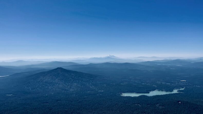
One of the things I love most about being up high is the perspective it can provide; and Mount McLoughlin is the highest thing between South Sister and Mount Shasta, in California. I had read that on clear days you can see both. Sure enough, to the south was the latter more than seventy miles away, its attendant foothills blurred, row after row of them, in a lovely soft haze. But when I swiveled around and looked north to South Sister, I saw just a couple of rows of foothills. The rest were lost under a shroud of gray smoke that stretched from west to east. Rising thousands of feet from the middle of the smoke was a great pyrocumulus cloud, presumably from the Emigrant Fire as it raged uncontained.
I blanched. Some perspective. The first big smoke year I remember, the one that signaled things were going to be different from now on, was ten years ago. More than one million acres burned during that summer of 2015—the most severe fire season Washington had experienced. A couple of years later, I listened to Jerry Franklin, an eminent forest ecologist, give a talk about wildfires at a conference in Portland. The session in which he spoke was about Large Infrequent Disasters, or LIDs. (I had gone to hear a talk about volcanoes.) Franklin said we should really worry when forests started burning with greater frequency on the west side of the Cascade crest, which is cooler and wetter than the tinderbox of the east. Off the top of his head, he guessed we had maybe twenty years before that would happen.
Actually we had three. In the summer of 2020, in the thick of other existential crises, smoke from millions of acres of regional wildfires burning both the east and west sides of the mountains drifted out over the Pacific, and then somehow was advected back to shore, smothering western Washington and elsewhere. Not even a good N95 mask was enough to keep out all the carcinogens in the air. For days no one who had a choice left their homes.
Atop Mount McLoughlin, I turned in my rocky seat and looked back to the south.
We left for Bend the following day. As we drove through a matrix of national forestland—Umpqua, Deschutes—I pointed out old fire scars to my daughter. On one side of the highway were blackened snags with orange needles clinging to the branches; on the other side the trees were still green, vibrant, untouched.
“Look at all the young vegetation growing on the burned side,” I said. “See how the forest is coming back.”
“Uh huh,” she said.
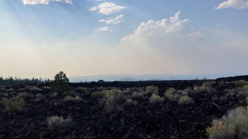
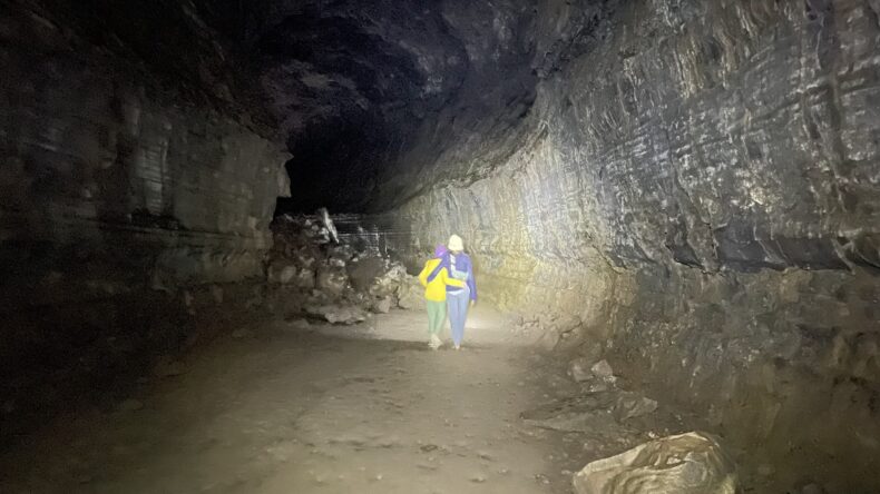
A few miles south of Bend we stopped at the Lava River Cave, part of the Newberry National Volcanic Monument. Smoke from the Emigrant Fire was so thick that when we got out of the car the sun’s light was the color of a halogen street lamp. We trooped to the cave with a scheduled group, bringing headlamps and warm coats. Beyond the cave entrance there would be no light, a ranger advised us, and the air temperature was a constant 42 ºF regardless of how sweltering it was outside.
We clanged down some metal stairs and hopped onto the cave’s sandy floor. The cave, which is more than a mile long, is a remnant of an eruption that took place eighty thousand years ago at Mokst Butte. A thick crust cooled over what had been an open molten stream, forming a roof, while lava ran on underneath. Once the eruption finished and the last of the lava drained, the cave was left behind.
As a space the cave was a marvel. Its walls were smooth, its ceiling rounded and cavernous, and glittering with flecks of crystal. To be deep in the earth was meditative, soothing. Perhaps because the air was so cool. Ours was the last group of the day, and midway along my family and I realized that most of the folks we had started with had turned back for whatever reason. For all intents and purposes we were alone. On impulse we turned off our headlamps and hugged each other and jumped around in the exhilarating cold darkness.
Afterwards we stopped by the monument’s visitor center. At the front desk, the staff were debating whether they should have closed early given how bad the smoke was. But they had not, so we went in to look at the exhibits. One, called “Landscape Of Change,” showed a triptych of South Sister, Newberry Volcano, and Mount Hood. The main text began, “The dynamic nature of the Earth’s environment is highly evident in the landscape of central Oregon.”
No kidding, I thought.
The next morning at our hotel my alarm went off at 6 a.m.. I had known when I set it I was courting violence, but the smoke forecast said air quality would be best in the morning before deteriorating in the afternoon, and I wanted to get an early start to our South Sister climb. I threw open the shades. A reddish sun was just peeking over a horizon of as-yet unveiled mountains—as fair an omen as I could reasonably hope for.
“Look how nice it is!” I said. “Let’s get going!”
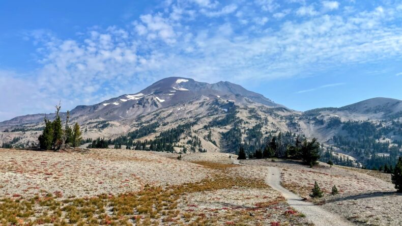
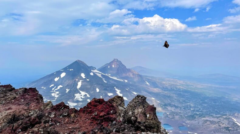
The drive to South Sister from Bend is about thirty miles, and we made good time. At the trailhead we shouldered our packs and set off. For the first couple of miles we wound through forest, and then we crested a slope and came to a rolling plain with only spare trees. The volcano rose in front of us; to our right was the jagged profile of Broken Top, the almost perfect cone of Mount Bachelor.
If I had been hoping the air would be miraculously clear, it was not. Broken Top and Bachelor were shadowy ghost mountains through haze. Even South Sister, at once tantalizingly close and dauntingly far, was slightly dimmed as if seen through a scrim. But the mountain came into vivid physical focus as we marched towards its prominence and, in due time, up it. At some point around nine thousand feet or so, we realized we had left the smokey blanket of the lower elevations. We knew this not by scent, but sight. The colors had become rich. A tarn below what remained of the Lewis Glacier was an irradiated turquoise. The pumice and other scree that made the slog up the Red Mile to the summit so hard was the shade of arterial blood. But we climbed towards the bluest of skies.
“We did it,” my wife said when we reached the top. “Are you happy?”
“Very,” I said.
“If we had been here when this was erupting thousands of years ago and spewing out lava,” she observed, “you would have been that caveman dad who said, Don’t worry, we’ll be fine, we can just walk around it!”
“Probably,” I said.
“… And then we all would have died,” my daughter finished.
I shrugged.
We found a windbreak of piled rocks and set our packs behind it, put on jackets, had a snack. While I munched I looked around. I have been on mountains where it feels like I can see forever, but that was not to be on South Sister. The smoke below allowed for ten, maybe fifteen miles of visibility at most in any direction. The promised monuments to the fires rising from the Earth were obscured by the fires rising above it; and so there would have to be other consolations. Oh, but there were. I took a deep breath, held it, let it fill my lungs. The wind carried traces of sulfur. The sky was filled with butterflies.
Photos by the author

This is lovely! Thank you, Eric!
Thank you thank you!