 At first glance, the prison camp at Guantánamo Bay doesn’t seem like much of a subject for archaeologists. The controversial camp, built to detain suspected terrorists after the 2001 attack on the World Trade Center, seems far too new, far too contemporary for archaeological research. And if that weren’t reason enough to steer clear, Gitmo remains firmly out-of-bounds to nearly everyone, a terra incognita behind barbed wire on an American naval base in Cuba.
But none of this stopped archaeologist Adrian Myers, who is currently finishing off his Ph.D at Stanford, from taking a good hard look at Gitmo and drawing up the first independent public maps of the facility.
 Myers, I should explain, is part of a new wave of archaeologists–mostly young, mostly unconventional–who are applying the standard methods of their trade to contemporary issues. Myers has a particular interest in modern internment camps and prisons, and he thinks archaeology can tell us much more about life in those grim barracks and cells than a stack of official government reports peppered with half-truths and omissions.
Two years ago, while playing around with Google Earth, Myers decided to navigate to Guantánamo Bay, curious if he could see the secret camp on the satellite imagery. He fully expected it to be blurred out, since Google Earth purchases its satellite imagery from private companies required to obey local laws, including regulations restricting the release of images of military installations and other sensitive sites. But there the camp was in a high-resolution image taken in February 2008. Myers was astonished. “I remember just saying holy crap, you can see it.”
Myers quickly downloaded the picture. Then he flipped over to Google Earth’s historical slider to look for other, older satellite images of Gitmo. There he discovered two more–the earliest dating to April 2003–and downloaded those too.
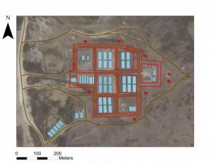
 As he studied the photos, Myers made out the familiar architecture of detainment: barbed-wire fences, guard towers and in some images a series of large rectangular boxes that were barracks. Then he compared the sequence of dated images to a terse description of the facility in a Wikileaks report, and began tracing the camp’s evolution over time.
In 2003, the detainees lived in simple plywood barracks surrounded by chain-link fences. But as the war on terror dragged on, the American government built a massive, permanent facility closely resembling a U.S.-style concrete supermaximum security prison. In just five years, the total floor space at Gitmo rose from 42,920 to 61,558 square meters.
Myers thinks that this explosive growth and the shift from makeshift barracks to a large concrete prison clearly revealed the intention of the United States government to hold detainees there without trial for a very long time. And he thinks the creation and publication of such an independent record of these facilities serves an important purpose: unlike government documents, this record can’t be shredded, obliterated, or manipulated later.
“Prison camps disappear really quickly when their use is up,” Myers says. “After the Second World War, the American government tried to strip away and bulldoze the Japanese-American internment camps. I don’t think it was interested in having this become part of the national record.”
Myers’ paper on his Guantánamo research can be found here, behind a paywall, in World Archaeology. But it’s just the beginning. One archaeologist I spoke with recently told me that he and his students are now using Google Earth satellite imagery to study the urban structure of the world’s 50 largest slums. Together, they are mapping these slums and looking at how cities cordon off these areas in hopes of containing the poor–rather than assisting them–and preventing them from seeping into wealthier districts.
I am fascinated by this new wave of archaeology. Using cheap off-the-shelf technologies, it is breathing new life into an important scientific discipline, one that many people dismiss at times as irrelevant.
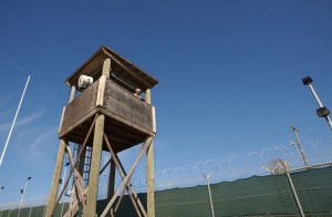
Photos: Upper, U.S. Army soldier stands inside a cell block at Guantánamo Bay prison camp. Courtesy U.S. Department of Defence. Middle: A U.S. Army soldier keeps watch from a guard tower at Guantánamo Bay prison camp. Courtesy U.S. Department of Defence. Bottom: Google Earth image of Guantánamo Bay prison camp in 2003, with map overlay. Courtesy Adrian Myers and Google Earth.
Interesting post.
I’ve been fascinated with tools like Google earth and what how they might be used (or could be used) in future.
The research about slums sounds fascinating also!