This post ran ten years ago, about a landscape that existed where the Bering Sea now lies, and how humans have been plying it from then till now. Living far inland in a desert environment, I don’t think of the sea often, but when I do, my mind flies to this tundra island, once the land-locked high point on the Bering Land Bridge, now the middle of a cold and churning sea.
Twelve Siberian Yup’ik men motored into the Bering Sea with two aluminum skiffs to visit relatives on the US side of the Bering Strait. Their journey retraced a route that has been used since the Ice Age, one of the most important lines of travel in human history.
Leaving the Russian coast, they traveled 70 miles through notoriously difficult waters to St. Lawrence Island, which is a far-flung piece of Alaska, a treeless hunk of tundra 90 miles long and little more than 10 to 20 miles wide. They came to the island’s only two villages, where residents are also Siberian Yup’ik, speaking the exact same language as their Russian counterparts.
Yup’ik people and their early relations have been on St. Lawrence Island for at least 2,000 years, traveling by boat back and forth all the while, but that is relatively recent history. During the Ice Age, this was not water at all, but entirely land. St. Lawrence Island was a high point in the middle of the Bering land bridge, as far from any coastline as Cincinnati, Ohio. Though evidence has been submerged under sea levels that rose up to 400 feet since then, it is believed that this is how people first reached North America.
More than a decade ago I visited St. Lawrence Island, stopping off for several days in the subsistence village of Savoonga where I was writing about sea level rise. It was enchanting to get out on the tundra and walk on one of the last standing remnants of the Bering land bridge, imagining the sea gone and mammoths grazing among shrub willow and open, windy steppe.
The first into the Americas, however, may not have been on foot, navigating off the ice-capped mountains of what would become St. Lawrence Island. A theory that gains popularity among archaeologists from time to time is a marine arrival, boat travelers. For much of the late Pleistocene, anyone crossing by foot would have eventually come up against a wall of ice on the North American side, 5 million square miles of the Laurentide and Cordilleran ice sheets blocking any further progress. By 17,000 years ago, glaciers were retreating along the coast, opening for the first time an ice-free route from Alaska down to Washington state, and from there into the rest of North America. It was the original entryway, best traveled by boat. The men who recently motored to St. Lawrence Island may have been showing us how it was done.
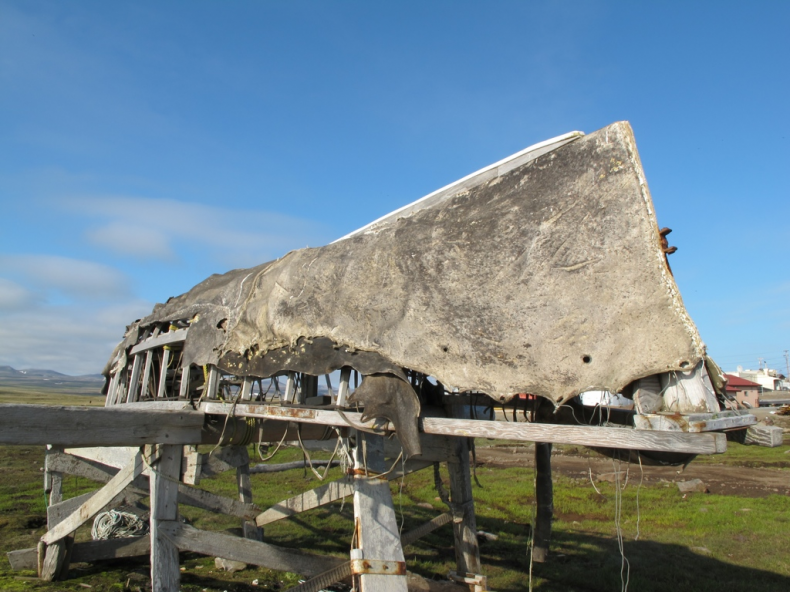
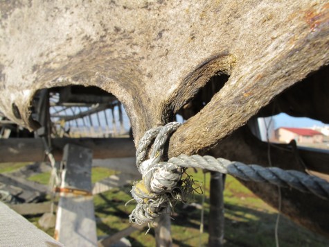
Instead of aluminum skiffs, older boats were umiaqs made of split walrus hides stitched together and stretched over a wood frame. The technology is ancient and circumpolar, used by almost every sea-hunting culture to have lived in the far north. I had a good look at these umiaqs at the edge of Savoonga where they’d been used recently enough they were up on two-by-four frames. Wind and sun had worn holes through their taut walrus-skin hulls, the hide half an inch thick, but weakening. None of the vessels were seaworthy without significant repairs. Each was large enough to fit 10-12 people, enough if you had a few of them to reach distant shores and start up new populations.
Even with the whole of the Pacific Ocean between them, Asia and North America were once connected around the edges by one long coastline. With sea levels down during the Ice Age, continental shelves were flying their flags around the world, and a person could have theoretically traveled, without ever losing sight of land, from as far south as Indonesia up the Vietnamese coast, the Korean Peninsula and the land-bound Japanese Archipelago to Kamchatka, around to North America via the southern Beringian coast, and all the way south to the sub-antarctic tip of South America. Archaeological sites from the late Pleistocene have been found all along this American coastline from the Channel Islands in southern California to Chilean Patagonia. The boats I saw in Savoonga may have used the same technology to get people to these hinterlands.
Humans were using boats by at least 48,000 years ago, when early signs appeared in Australia. Getting enough people to that continent to maintain a population had to have happened by a means other than swimming or clinging to driftwood. Other sites all along the Pacific Rim were occupied at least 40,000 to 35,000 years ago where people could have only arrived by some kind of watercraft.
As for actual remains, the oldest known boat along the Pacific Rim go back at least 6,800 years. Found along the southern coast of the Korean Peninsula were fragments of a wooden vessel found at a Neolithic-Bronze Age site. A piece of planking and part of a hull came up in the excavation, firm evidence of one of the oldest known boats in the world.
The boat of 17,000 years ago is entirely a matter of conjecture. What is clear, though, is that people could have done it. Even though aluminum skiffs are in use now, migrations into North America continued across the Bering Strait long after the land bridge went under, when they would have used vessels made of hide.
I recently spoke with a man who had been a radio operator on an American ice breaker during the Cold War. Mapping the submerged continental shelf under the Beaufort Sea north of Point Barrow, Alaska, he said that his ship, the USS Burton Island, was stopped hundreds of miles from the nearest land in a heavy fog when what he described as a canoe with 10 “Indians” aboard appeared. His description sounded like a umiaq, and its occupants, using wooden paddles, were all men. They boarded his ship and said they wanted to see a movie.
He couldn’t remember what movie they watched, but he said they came in and sat through one projected on a screen in the galley. After eating a meal of meat and potatoes, they climbed a ladder back down to their boat, cast off and disappeared, leaving behind the enormous metal ship, its various radars spinning, breeze humming through radio towers.
What struck him was how cavalier they were. “They knew exactly where they were going,” he said.
Photos: Craig Childs

