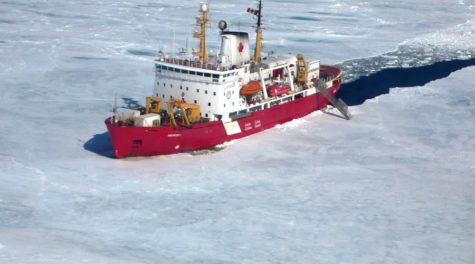
 When the official photographer’s helicopter hovered above the Arctic Ocean for the bank note photo shoot, the Canadian Coast Guard ship Amundsen carried Jay Cullen’s oceanographic research equipment prominently on its deck. The icebreaker was to feature on the red Canadian fifty-dollar bill, and Cullen saw his chance at immortality. Unfortunately, when the mint released the note, the artist had airbrushed out Cullen’s crates like so much clutter.
Cullen has been going up to the Arctic for ten years now, taking measurements of chemical tracers in ocean waters to track the changes in currents. But over the last three years, Cullen’s techniques have been put to use for another task: tracking the radioactive material released by Fukushima.
Seven years ago, when a 130ft-tall wave broke over Japan, travelling as far as 10 kilometers inland, almost 20,000 people were killed and three of Fukushima’s six nuclear reactors melted down and released material into the atmosphere and ocean.
The atmospheric release took eight days to reach Cullen’s home in Victoria, British Columbia, and most of it ended up in the North Pacific. Ultimately it will be transported to the Arctic Ocean. Unlike the air-borne material, the water-borne release took a lot longer to spread, reaching the West Coast of North America starting in 2014.
It didn’t take that long for the Internet to blow up with misinformation about the risks to life and limb that these releases posed. Part of the problem was that there was a vacuum of scientifically sound information, because the researchers were waiting on the data. Well, now the data is pretty much in.
Cullen’s measuring devices take samples down to a depth of 5,000 meters.
“We’re measuring a part per trillion of these metals in seawater. This can be hard because we are sitting on a giant piece of metal floating on the ocean,” says Cullen.
An army of citizen scientist surfers and residents all along the B.C. coast has also been sending in their samples showing the radioactive material in very low levels there. Looking over the horizon, 1,500km offshore the researchers can see that these levels are already dropping.
There is a history of radioactive contamination in the North Atlantic, and most of that was committed in the late 1950s and early 60s during nuclear weapons tests in the atmosphere. Most of the radioactivity we see in the Pacific still comes from those activities, and Fukushima’s levels are a factor of ten lower than peak levels during the middle of the 20th century. Current levels from Fukushima are equivalent to the fallout background levels of the 1970s. They are not unprecedented or known to cause harm. But they remind us that things could get worse.
“There is a lot going on right now as far as nuclear weaponry is concerned, and there is a possibility of an atmospheric test again,” says Cullen. “this is something I and my colleagues are paying close attention to, and it could have much more impact than the Fukushima disaster.”
Meanwhile, Cullen travels 12,000 km over a summer in the icebreaker, taking measurements off the coast of Baffin Island, threading the Arctic Archipelago, through the Beaufort Gyre and around the Mackenzie River plume. He can use the radioactive materials as tracers to show the changes in circulation as melting sea ice creates a surface covering of fresh water over saline.
Contaminants like dissolved cadmium and mercury go hand in hand with biological hotspots in the Arctic, because they come from nutrient-rich North Pacific waters. Cullen uses these tracers to predict where those waters are going to surface and nourish plant productivity. Wherever there is pollution, there is Arctic life to drink it up.
One thought on “Fukushima’s legacy in the Arctic Ocean”
Comments are closed.