 I’ve probably said this before, but I really like maps. In college, I bought a huge collection of used maps at a geography department sale to use as wrapping paper. When we lived in Oregon, we got a gigantic one of the state to put on the living room wall. (We also got an even bigger one of California, which should have been a clue that we might come back.) And there’s a poor cartographer who I keep interviewing without a story in sight, just because his job seems so cool.
Recently I came across two different kinds of maps, both showing how our life here influences the very globe that’s being mapped.
The design group Fathom, based in Boston, has been making maps that consist solely of roads. Oh, you’ve got me, they’re not actually made of macadam, but the maps have no country borders, no state lines—just roads. (The Washington Post has a quiz inspired by these maps–you’ll likely be able to identify many cities simply by their street grids.)
Even without these artificial designations, the maps still show how we’ve created boundaries with the highways and byways we’ve built: it’s not too hard to see the familiar outlines of our constructed geography, as well as the mountains, canyons, and other natural features that have, so far, resisted our inroads.

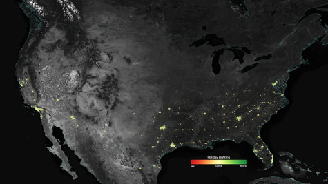
One thing I cannot resist (besides terrible segues) is holiday lights. We only just took ours down yesterday, and I was sad to see them go. And I know I’m not the only one who loves these twinkly decorations—particularly because images from a NOAA/NASA satellite have captured the increasing brightness of U.S. cities around the winter holidays. Scientists using the satellites also spotted the greater nighttime sparkle of many spots in the Middle East during Ramadan, when daily fasting shifts more activity into the lighted night.
Those maps look like decorations themselves, with darkness broken up by glints of life and light. People have been making decorations like these—helpful, necessary decorations– for many thousands of years. A rock at an archeological site in the Czech Republic may show the mapmaking urge from more than 25,000 years ago, while hunting routes may be illustrated on 14,000-year-old rocks in Spain.
But these days I’m finding myself more interested in those swaths of darkness, in those blank spots where no roads appear. These maps, and others, mark off the places where we’ve been, what we’ve named and seen and done, the lights strung, the road poured. Maybe it’s time to take the maps down from the walls and to stop calling the mapmaker. Time to enter the land of the dragons, and map it for myself.
**
Top Image
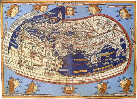
A medieval depiction of the Ecumene (1482, Johannes Schnitzer, engraver), constructed after the coordinates in Ptolemy’s Geography and using his second map projection, via Wikimedia Commons
One thought on “A Few Good Maps”
Comments are closed.